

A Pacific storm struck the Southland today, generating rain and snow, creating treacherous travel conditions across the area and raising fears of flooding and mudslides in areas stripped bare by the Woolsey and Holy fires.
As of noon, Long Beach Airport had received about .63 inches of rain. No significant flooding has been reported.
“So far so good,” said Gonzalo Medina, Long Beach Fire Department’s chief of marine safety.
The city is clearing storm drains and removing debris from basins to allow for the flow of stormwater. The swiftwater rescue team is also deployed for the next 36 hours to respond to waterways in the city, Medina said.
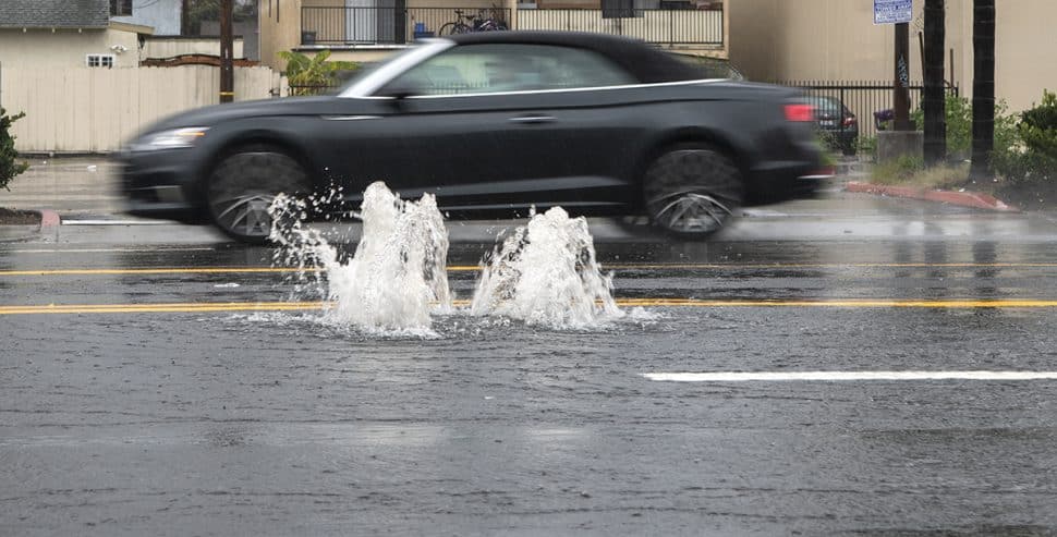
There was some minor flooding, including water bubbling up from under the pavement, at Orange Avenue and Pacific Coast Highway Monday afternoon.
“In that area, the water tends to pool,” Long Beach Fire Department spokesman Matt Dobberpuhl said, but so far, fire officials hadn’t responded to any major rain-related issues.
The city expects heavy rains for the next 36 to 72 hours.
Early Monday morning, the National Weather Service issued an Urban and Small Stream Flood Advisory for western Los Angeles County due to the persistent rain falling in the area. That advisory was allowed to expire at 9:30 a.m.
Monday’s storm was expected to produce between a half-inch and 1 1/2 inches of rain and up to 2 1/2 inches in the mountains and foothills, NWS meteorologist Todd Hall said. Two more storms are expected to roll through the area this week, generating between 3 and 6 inches of rain in coastal valleys and 7 to 9 inches in mountains and foothills, he said.
“It’s going to be a very wet week for Southern California,” Hall said.
NWS forecasters warned that despite the already-wet morning, the bulk of Monday’s storm likely would not arrive until the afternoon, particularly in Los Angeles County.
The rain is “expected to decrease in intensity and coverage this evening, then start to increase again later tonight and especially Tuesday as the next impulses arrive,” according to the NWS. “This one may be the strongest of the week, with a strong southerly component to the low level winds and good instability, especially in the afternoon.”
A winter storm warning denoting potentially perilous conditions will be in effect in the San Gabriel Mountains until 10 a.m. Tuesday, according to the NWS.
Heavy snow is expected, with snow accumulation of 6-12 inches anticipated above 5,000 feet and 1-3 inches between 4,000 and 5,000 feet, according to the NWS. There also could be light slow accumulation down to 3,500 feet, which could affect Interstate 5 through The Grapevine. At the same time, “damaging” winds of 25-35 mph gusting at up to 60 mph will buffet the northwest San Gabriels, including the Interstate 5 corridor, the weather service said. But no other warnings of high winds were issued for any other part of L.A. County early this morning.
“Plan on difficult travel conditions, including during the evening commute on Monday and the morning commute Tuesday. Be prepared for significant reductions and invisibility at times,” according to the NWS statement discussing mountain conditions. A Winter Storm Warning for snow means severe winter weather conditions will make travel very hazardous or impossible.
Along the L.A. County coast, breaking waves of 4 to 7 feet, with maximum sets of 8 feet, are expected, increasing to 5 to 8 feet this afternoon through Tuesday, according to the NWS. The high surf then is likely to continue Tuesday night through Friday.
The conditions create “an increased risk for ocean drowning,” warned an NWS statement on maritime conditioms.
“Rip currents can pull swimmers and surfers out to sea. Large breaking waves can cause injury, wash people off beaches and rocks, and capsize small boats near shore.”
Forecasters warned swimmers who get caught in a rip current to “relax and float. Don’t swim against the current. If able, swim in a direction following the shoreline. If unable to escape, face the shore and call or wave for help.”
Staff writers Jeremiah Dobruck and Stephanie Rivera contributed to this report.