

El Cordonazo de San Francisco, or the Lash of St. Francis, is the name for the killer hurricane winds and tropical cyclones that fairly regularly terrorize the West Coast of Mexico and Central America in the late summer, around the Oct. 4 feast day of St. Francis. It’s an aptly ferocious term that accounts for a reasonable fear in the countries it ravages.
It certainly sounds sinister enough to those of us in Southern California where we prioritize our fears, giving greater weight in our triage of tragedy to fretting about earthquakes, wildfires, drought and heat. But 80 years ago on Sept. 25, the lash came down on Long Beach, Los Angeles and coastal cities from Point Magu to Huntington Beach, hitting land near San Pedro, in the first time that a tropical storm spawned by a hurricane made landfall in Southern California.
The El Cordonazo winds and rains came unexpectedly and suddenly, startling some Long Beachers who had hit the strand that Monday during a searing summer heat wave that brought record-breaking temperatures of 103 degrees just a few days earlier—and now a tropical storm was whipping up gusts of 45 mph. Lifeguards rushed to close the beaches, and as gales reached 65 mph, the Navy deployed four new destroyers attached to the Battle Fleet, and the Coast Guard added a pair of cutters to rescue boaters in the Catalina Channel.
In all, 48 people were killed in California, including 24 aboard the vessel Spray (two passengers survived) as it was attempting to dock near Point Magu and 15 aboard the Ventura fishing boat Lur.
The storm turned the sea into a raging force as huge waves pummeled the Alamitos Peninsula and Belmont Shore, yanking 10 homes off their foundations and washing them out to sea, while reducing scores of others to driftwood kindling.
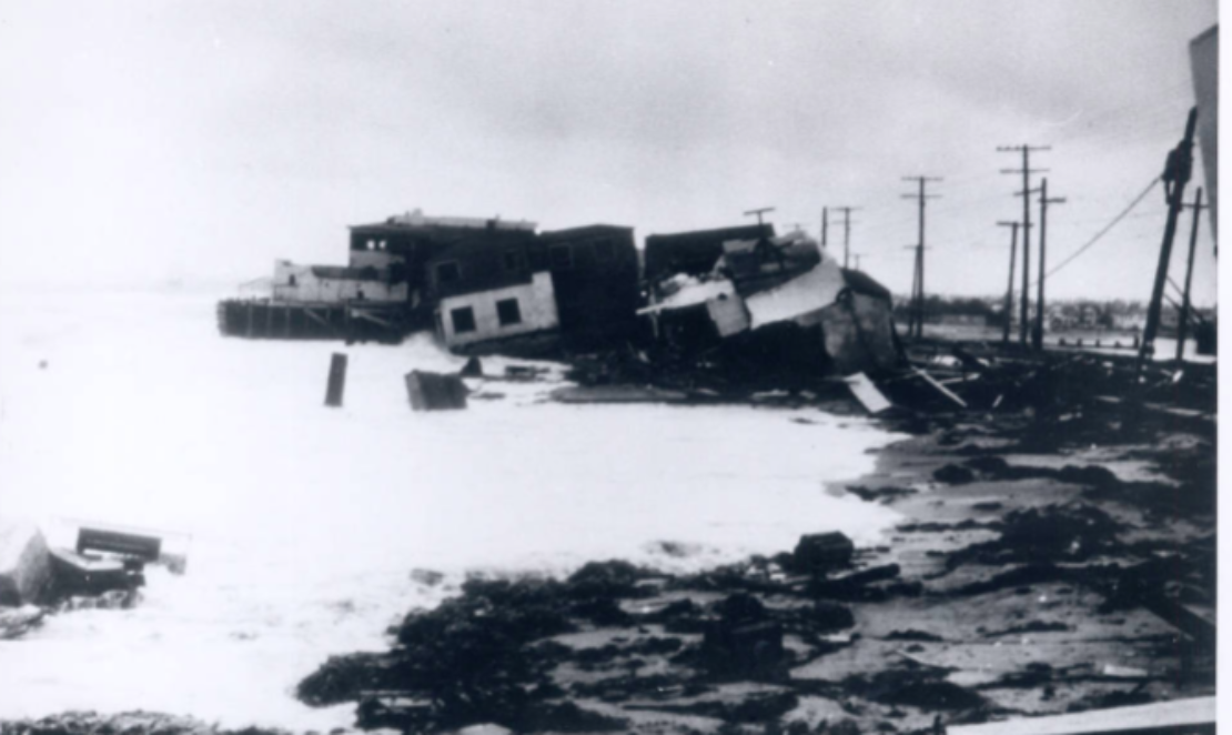
Homes flooded all along the coast, as nearly 5.5 inches of rain fell, making it the worst rainfall in the month of September in L.A., swamping the 1919 mark of 1.29 inches.
The wind shattered windows in Long Beach and the flood basin of Hamilton Bowl overflowed, turning Signal Hill into a virtual island, with streets two to three feet underwater.
Residents of coastal communities of Long Beach, especially those on the Peninsula, still point to the Lash of St. Francis as a good reason to preserve the breakwater, and many have added fears of hurricanes hitting Southern California to their list of apocalyptic fears.
With serial hurricanes destroying islands in the Caribbean and the Atlantic as well as the Atlantic seaboard states from Florida to New York City and all of the Gulf states, it’s not unreasonable for Southern Californians to wonder if in these days an increasingly wrathful planet will bring a full-fledged hurricane to these shores.
And, when you worry about future climatic calamity, you need to make a call to Bill Patzert, recently retired from NASA/JPL and one of the world’s foremost climatologists and oceanographers.
El Cordonazo, he says, is a regular occurrence in Venezuela, Panama and the west coast of Mexico, but “what we usually get are the remnants from these hurricanes, like the big tropical storm of 1939.”
The odds of a full-blown hurricane striking California, says Patzert, are infinitesimal—”so small that everyone should just relax.”
Hurricanes gather their power from warm water, and “the thing that is a hurricane killer is the cool waters off the California Current,” which moves southward along the coast from British Columbia down to the southern tip of Baja California.
“The magic number for hurricanes is 80 degrees,” said Patzert, “and the farther north you get from Cabo San Lucas, the cooler the water gets, between 60 and 70 degrees. The other thing that mitigates hurricanes is the steering winds in the Pacific that tend to knock the top off hurricanes.”
So a hurricane hitting Southern California “is not our worst nightmare,” says Patzert. “The big events here in Southern California are atmospheric river events, when rain hits like a firehose for a week or two or maybe longer.”
Atmospheric rivers are, as the name suggests, long, narrow regions in the atmosphere that carry water vapor from the tropics and release it in massive torrents when it reaches land. “The Pineapple Express” is one you’ve perhaps heard of. And these have hit Southern California a number of times, including 1938, just a year before the Lash of St. Francis, when 96 Southern Californians were killed by floods and mudslides, including 10 in Long Beach who were washed out to sea when stormwaters took out a large section of the Third Street Bridge spanning the L.A. River. Throughout the state more than 1,500 homes were rendered uninhabitable, leaving 3,700 residents sheltered by relief organizations.
More recently, there was an atmospheric event in September 2015, which brought 3-4 inches of rain to L.A., but nowhere near the disasters that storms brought in 1938 and 1934, in which rains destroyed more than 400 homes and killed scores of residents in the La Cañada and La Crescenta areas of Los Angeles.
Much of the potential damage from rain has been allayed by the cementing of the Los Angeles, San Gabriel and Santa Ana riverbeds, and that taming of the rivers was brought about by the storms of 1938 and 1939. Prior to the flood control, most of the land between Pasadena and Long Beach, says Patzert, was one big flood plain, which, as flood plains will, went underwater during a storm of any size.
So, while the regions suffering the most hurricanes in the world, Patzert says, are the West Pacific, at No. 1, followed by the East Pacific, the hurricanes that hit the eastern part of the U.S. and those in the Gulf of Mexico continue to soak up all the ink in the press, and with good reason. The climate catastrophe continues unabated, putting much of Florida on the precipice of uninhabitability and regularly pummeling states along the Atlantic Ocean.
In terms of hurricanes on the East Coast, Patzert says, “The fat lady hasn’t sung yet.”
Nor has she sung here. Some residents on the Alamitos Peninsula and in Belmont Shore, at least those who place some credence in science, may be nervous about the specter of rising sea levels and its effect on their ocean- and bay-front properties in the coming years. Will their homes be destroyed or rendered uninhabitable? Will they be forced to relocate through managed retreat?
Those are some subjects that will be addressed at a free community event from 7 to 9 p.m. on Oct. 7 at the Aquarium of the Pacific’s Ocean Theater. “Coping With Sea Level Rise With a Focus on Long Beach’s Peninsula and Belmont Shore.”
The featured speaker is Gary Griggs, the distinguished professor of Earth and planetary sciences at the University of California Santa Cruz and author of several books, including “Coasts in Crisis: A Global Challenge.” Also speaking will be Sylvain Barone and Laura Michels, both from the University of Montpellier. Barone’s work includes research on coastal risks and climate change, and Michel’s area of expertise include sustainable development strategies.
There is no charge, but you need to RSVP by calling Aquarium Guest Services at 562-590-3100, ext. 0.